
Highway author's top 10 road trips (plus 2)
Stephen H. Provost
I’ve spent bits and pieces of the past few years traveling around the country on various highways, and now, here I am, confined to quarters by the coronavirus outbreak. Fortunately, I’ve got my memories and a few photos to keep me company, so I thought I’d share a few of those with you in the form of my favorite stretches of highway ... so far. (I’ve still got a lot of road trips ahead of me, once this thing lifts.)
So far, I’ve produced three highway books: on Highway 99 and Highway 101 in California, and a tome called Yesterday’s Highways about the federal highway system founded in 1926. Next up: America’s First Highways, a look at America’s auto trails, the privately run hodgepodge of half-built highways that crisscrossed the country in the early days of the automobile.
So, without further ado, here are my top 10 stretches of highway, in reverse order, and certainly subject to change once I’m back on the road again.
12. Old Plank Road, California

This isn’t exactly a trip on a highway, it’s more a trip to a highway. The Old Plank Road is a stop along Interstate 8 in Imperial County, Southern California, heading east toward Arizona. There’s not much left of it today, but you can still see some of the original wood planks from the roadway, as well as a reconstruction of what it once looked like, The wooden road was built in 1915 to help cars traverse the shifting sands of the Algodones Dunes, then rebuilt a year later. There’s a fascinating story behind it all, including a road race to establish the best route for the road, which you’ll find in Highway 99: The History of California’s Main Street, as well as in America’s First Highways.
11. National Old Trails Road, California

This stretch of highway was known as Route 66 for four decades, and there are still highway shield signs stenciled into the road along the way, but these days, street signs (and Google Maps) call it the National Trails Highway. It’s a variation on its earlier name, the National Old Trails Road — a series of “old trails” pieced together to provide a way across the continent. Some were little more than rutted wagon-wheel paths, and there’s that same feeling of loneliness to this stretch of highway that there must have been back then. It almost feels like you’re driving on the moon, until you come to an old, abandoned filling station or Roy’s Motel and Café (pictured above), which is still open in the otherwise abandoned hamlet of Amboy. It was 114 degrees when I was passing through on this section of road in a car without air conditioning. Needless to say, I bought a lot of water at Roy’s. You’ll find more about this trip in Yesterday’s Highways.
10. Lincoln Highway, Pennsylvania

I got a chance to explore this section of what’s now called U.S. 30 but started out as the Lincoln Highway, the early 20th century’s most ambitious cross-country route. Planned by Carl Fisher, the same man who built the Indianapolis Motor Speedway and transformed Miami Beach from a backwater hamlet into a booming resort, the Lincoln Highway ran from New York to San Francisco. There’s a lot to see on many sections of the road, but Pennsylvania was my favorite. You’ll pass through historic Gettysburg — and past the site of the historic battle (pictured above) — and you’ll cross one of the most impressive Columbia-Wrightsville Bridge. When it was dedicated in 1930, it was the world’s longest multiple-arch concrete bridge, and the fifth built at that location. The old Lincoln Highway will also take you past Latrobe, childhood home of Arnold Palmer and Fred Rogers, and birthplace of pro football and the banana split. But the highlight for me was the beautiful Allegheny Mountains, rolling hills that find the perfect balance between repose and majesty. For more on the Lincoln Highway, check out Yesterday’s Highways and my forthcoming book, America’s First Highways.
9. Old Ridge Route, California

You can drive some of the way along the first highway to span the Tehachapi Mountains, linking Northern and Southern California, although part of it’s blocked off by the U.S. Forest Service. What you can see is fascinating. When it was established back in 1915, a number of local businesses set up shop along this narrow, winding path at the top of the world. Most of them abandoned it when an alternate route went in at a lower elevation to the west in the early 1930s, and only a very few remnants of that first era remain visible. Still, you can imagine what it must have been like to drive along the concrete road at 15 mph (the speed limit) and hope you didn’t run into a truck coming the other way around Dead Man’s Curve, which you can still see from above if you take a detour through Lebec. You can travel portions of the 1930s-era alternate route, too, although it was eventually bypassed itself by Interstate 5. Part of it’s down at the bottom of manmade Pyramid Lake. For more details on the Old Ridge Route, check out Highway 99: The History of California’s Main Street.
8. Highway 101, San DIego County

If you want a look at what the first federal highway system was like, before the age of the interstates, this section of highway is a great example. Sure, you can continue down Interstate 5 if you’re traveling from L.A. to San Diego, but why not take your time and drive south from Oceanside through, Carlsbad, Encinitas and Del Mar on a section of road that’s still signed as U.S. 101. The 10-mile Oceanside-Carlsbad Freeway at the north end of the route was started in 1950 to improve the flow of traffic and was the first modern highway in the San Diego area. Still, it passes directly through both cities’ downtown area and, farther south, offers beautiful views of the ocean. The section through Del Mar and past the historic racetrack/fairgrounds is gorgeous, and you’ll pass iconic businesses like the 1928 La Paloma Theatre in Encinitas and the 101 Café (pictured above), built that same year in Oceanside. The latter is worth a stop to check out the cool ’50s-throwback mural on the side of the building. More: Highway 101: The History of El Camino Real.
7. Blue Ridge Parkway, Virginia

This 469-mile parkway through Virginia and North Carolina runs along the spine of the Blue Ridge Mountains. Most of what you’ll see is natural beauty, and boy, is there a lot of it. Green rolling hills, scenic overlooks, trees and wildflowers abound. Mountain ridges hug rolling meadows on this scenic drive. There’s aren’t many historic buildings along the way, but it’s worth stopping to check out Mabry Mill (pictured above), a site that features a sawmill, blacksmith shop and other buildings that date from the early 1900s. I haven’t driven the North Carolina section of this road yet, but I suspect it’s every bit as beautiful.
6. Highway 99, Dunsmuir, California

The town of Dunsmuir is a hidden gem, where you’ll find some of the cleanest water around. The old alignment of former U.S. Highway 99 takes down of Interstate 5 as you head north into town along Dunsmuir Avenue and past the historic California Theatre, which dates back to 1926. We stayed outside town at the Cave Springs Resort, a historic auto camp with cabins that date back to 1923 but that’s still running as a motel today. Railroad Park Resort, just south of Dunsmuir, offers lodging and eats inside refurbished railroad cars. Also south of town, you can check out the wild rock formations known as Castle Crags, which live up to their name. And the pine trees? They’re all around! More: Highway 99: The History of California’s Main Street.
5. U.S. 11 / Lee Highway, Virginia

This section of highway follows the course of an early cross-country auto trail called the Lee Highway, named for Confederate Gen. Robert E. Lee. But west of Wytheville, it doesn’t seem much like a highway at all. Long since bypassed by Interstate 81 just to the north, it’s one of the most enchanting two-lane country roads you’ll find. Out of the blue, you’ll pass an old drive-in theater like the Hiland in the aptly named Rural Retreat. It opened in 1952 and is still operating today. Or you’ll find yourself passing the 1832 Old Stone Tavern in Atkins, that dates back to the time when the highway was a stagecoach route. There’s another historic theater in Abingdon, the Moonlite, which opened in 1949 and was placed on the National Register of Historic Places in 2007. Unfortunately, it closed six years later. Abingdon itself is a treasure trove of history, featuring an old theater, an 18th century tavern (foreground above), a grand 19th century women’s college and much more. This highway would make the list for Abingdon alone. More: America’s First Highways.
4. Pacific Coast Highway, California
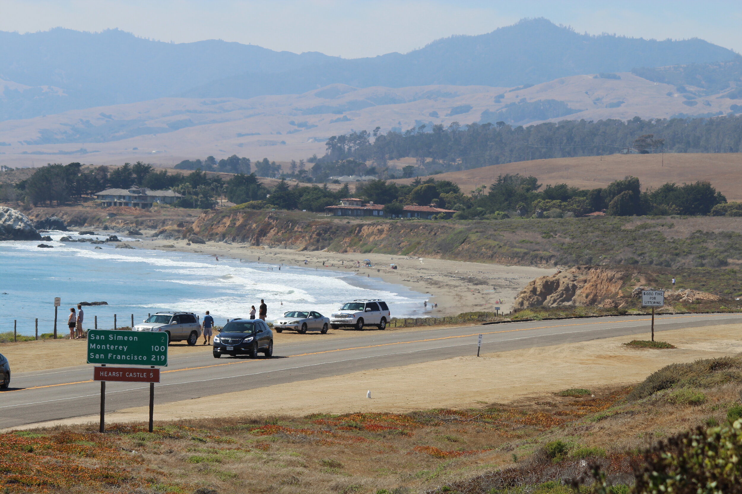
It’s hard to pick a specific section of this highway, which is routinely rated as the nation’s most picturesque. The section through Malibu is plenty interesting, too. But this segment, which features Big Sur, the iconic Bixby Creek Bridge, an elephant seal rookery, and the ever-intriguing Hearst Castle (with zebras grazing by the side of the road!), is everyone’s favorite. I lived a couple of miles away from State Route 1, as it’s technically known, for about six years, so I got spoiled. While working as a journalist, I even covered the road’s reconstruction after a couple of big mudslides washed sections of it into the ocean. The road north of San Simeon is full of curves and hairpin turns that offer breathtaking views of the ocean. It will take you a lot longer to get up the coast than it will if you travel the inland route (U.S. 101), but the scenery you’ll see is worth the extra time. More: Highway 101: The History of El Camino Real.
3. Route 66, Desert Southwest
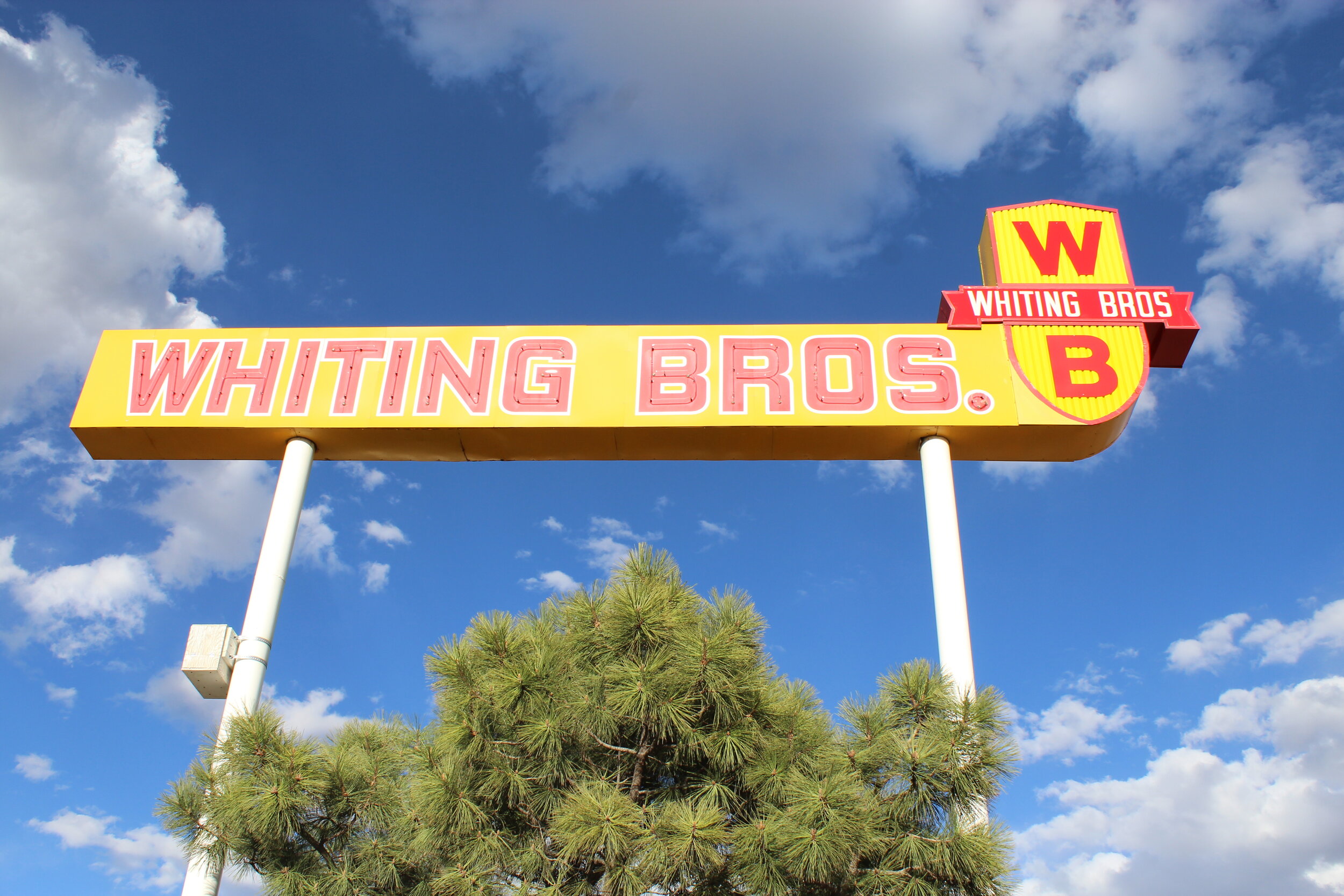
It’s about 500 miles from Glenrio, Texas to Winslow, Ariz., and you can make the trip in about a day. If you don’t stop. But you’ll want to stop many times along the way to check out what’s left the heart of Route 66. Glenrio’s a ghost town at the Texas-New Mexico state line, where you can find dozens of abandoned businesses: motels, diners and homes. It was an entire town, but virtually no one lives there now that Interstate 40 made Route 66 an afterthought – except to nostalgia buffs. Just a few miles west in Tucumcari, you’ll find plenty of old motels and service stations, some of them refurbished and plastered with colorful murals. The highlight here: the still operating Blue Swallow motel, with its distinctive neon sign, that opened in 1940. You’ll see plenty of other old Route 66 businesses along this stretch of highway, including several of the now-abandoned Whiting Bros. service stations that once dominated this section of road. The chain was once based in Holbrooke, and just west, in Winslow, you’ll find a statue inspired by the Eagles’ song Take It Easy, with its reference to “standin’ on the corner in Winslow, Arizona.” More: Yesterday’s Highways.
2. Redwood Highway, California

There’s simply nothing like the 140-mile section of U.S. 101 through Northern California known as the Redwood Highway. Starting at the south end of this segment in Ukiah, you’ll pass by the historic art deco Regal Ukiah Stadium 6 cinema, built in 1948, and the World’s Largest Redwood Tree Filling Station, carved out of a tree felled in 1936, when the station started pumping gas. Then, in Willits, you’ll pass beneath the distinctive neon arch. But the real attractions are the trees themselves, which line a section of the older U.S. 101 (now State Route 254) called the Avenue of the Giants. It parallels the current 101 from Phillipsville north to just short of Stafford. Before you get there, stop at the Benbow Inn in Garberville which dates back to the 1920s and offers some high-class atmosphere and the best hamburger you’ve ever eaten. Trust me. Other stops along the way include the drive-through Chandelier Tree and Confusion Hill, a 1949 tourist stop in Piercy. There’s too much to mention here, but there’s plenty in my book Highway 101. More: Highway 101: The History of El Camino Real.
1. Road to Hana, Maui

This will always be my favorite. I’ve driven it three times, at three different times of my life, and it never fails to disappoint. Yes, you have to make your way carefully over nearly four-dozen one-lane bridges and around more than 600 curves, but that’s part of the road’s charm. It will take you four hours to get to Hana, which might take you an hour if you could take a straight shot. The thing is, you can’t. Besides, Hana Highway is about the best evidence ever that it’s about the journey, not the destination. There’s not really much in Hana, a sleepy town of barely 1,200 people, but along the way you’ll pass through the nation’s only true rain forest. Along the way are gorgeous seasonal waterfalls, eye-popping ocean overlooks, bamboo forests, black sand beaches and lava tubes. Plus, it’s just fun to drive. It’s almost like a roller-coaster: Merchants even sell T-shirts that proclaim you’ve driven the Road to Hana. This one should be on everyone’s bucket list. (For a bonus trip, drive up the crater road to Haleakala, Maui’s extinct volcano. You’ll view the island and surrounding ocean from above the clouds. But take a jacket. It’s cold up there!)
All photos © Stephen H. Provost, 2015-2020